
 ← All stories
STORM FILE · Stormchasing
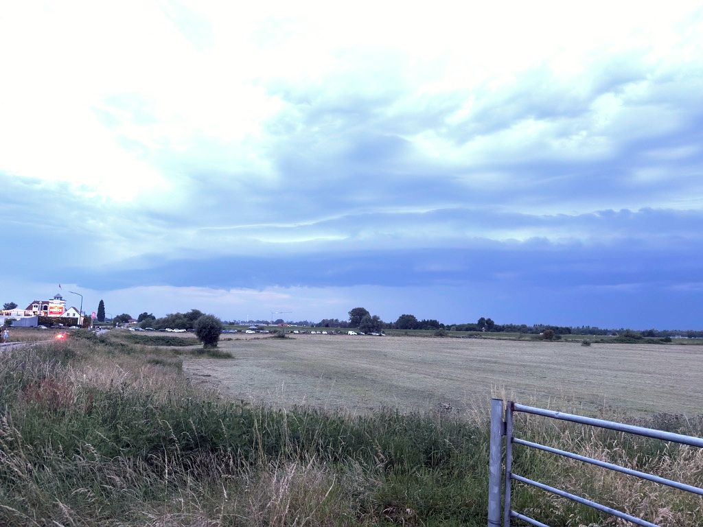
A dark shelf cloud moves over the meadows near Culemborg. Above it are blue-grey layers of cloud, with the horizon growing darker. I've driven to the Netherlands to intercept and photograph the forecast storm.
Diesen Beitrag anhören
Dauer: 3 Minuten 10 Sekunden
MP3 herunterladen · 2,3 MBStimme und Quelle
Thorsten-Voice / Piper. Sprecher Thorsten Müller. Stimmaufnahmen unter CC0. Thorsten-Voice.
Listen to this article
Duration: 2 minutes 57 seconds
Download MP3 · 2.1 MBVoice credits
Alba / Piper. Alba speech corpus (2019), Cassia Valentini-Botinhao and Junichi Yamagishi, University of Edinburgh. Voice recordings licensed under CC BY 4.0 and used to train a synthetic voice. The article is by The Adventure Beyond.
Beluister dit artikel
Duur: 3 minuten en 46 seconden
MP3 downloaden · 2,7 MBStem en bron
Ronnie / Piper. Stemopnamen van OHF-Voice, beschikbaar onder CC0. Stemgegevens en bron.
01 / FIELD NOTE
Approaching from the southwest
First, I watch a storm cell over Belgium heading towards Antwerp. It moves from southwest to northeast. I look for a spot along its route with enough time to set up.
Near Culemborg, the open countryside gives me a good view of the approaching shelf cloud. I can already see lightning on the horizon.
02 / FIELD NOTE
Between cloud structures and lightning photography
The camera is ready. The sky changes in front of me as I try to capture lightning as well as clouds. The remaining daylight makes it difficult: it is still quite bright for photographing lightning.

At one point, I call my son to say goodnight. He asks me to take care. I remember that just as clearly as the storm.
Guests at the nearby café are leaving. I stay with my camera, watching the layers of cloud come closer.
03 / FIELD NOTE
When the storm reaches Culemborg
Then the shelf cloud passes over my position. Gusts, heavy rain and small hail follow shortly afterwards.
04 / FIELD NOTE
Following the front
Afterwards, I follow the front northeast towards Arnhem. Lightning is still visible, but woodland increasingly blocks my view.
The front continues north-northeast, and eventually I head home. The shelf cloud and its passage with gusts, heavy rain and small hail are what I remember most from this trip.
05 / FIELD NOTE
The storm on the radar map
This stormchasing trip was on 19 June 2026. The historical radar sequence shows rainfall around Culemborg, Rhenen and Arnhem. All three are marked. My own photos from Rhenen were taken late that evening.
Radar sequence as text and a data table
Text alternative for the silent radar animation: 24 consecutive hourly rainfall totals on 19 June 2026, with times in CEST. The map covers the Netherlands, Belgium and western Germany; north is at the top. The numbers can be read without distinguishing the map colours.
Each location value comes from the 1 km radar grid cell at that location. The four map regions show the highest available value in each quarter of the animation's map area, adding a regional view to the local readings. These are radar-based hourly rainfall totals in millimetres, not lightning data or exact ground measurements. ‘No data’ means there is no coverage; 0.0 means a valid reading with no measurable rainfall.
Animation key, in millimetres per hour: below 0.1; 0.1–0.5; 0.5–1; 1–2; 2–5; 5–10; 10–20; 20–40; 40 or more. Each upper limit is excluded. Hatched areas have no radar data.
| Time / CEST | Culemborg | Rhenen | Arnhem | North-west map | North-east map | South-west map | South-east map |
|---|---|---|---|---|---|---|---|
| 00:00–01:00 | 0,0 | 0,3 | 0,0 | 15,9 | 1,2 | 27,4 | 0,5 |
| 01:00–02:00 | 0,0 | 0,0 | 0,0 | 12,1 | 22,2 | 28,3 | 24,5 |
| 02:00–03:00 | 0,0 | 0,0 | 0,0 | 3,3 | 19,7 | 7,5 | 16,4 |
| 03:00–04:00 | 0,0 | 0,0 | 0,0 | 2,5 | 18,7 | 4,6 | 5,0 |
| 04:00–05:00 | 0,0 | 0,0 | 0,0 | 0,0 | 22,8 | 2,9 | 2,9 |
| 05:00–06:00 | 0,0 | 0,0 | 0,0 | 0,0 | 23,2 | 0,0 | 1,2 |
| 06:00–07:00 | 0,0 | 0,0 | 0,0 | 0,0 | 13,3 | 0,0 | 0,2 |
| 07:00–08:00 | 0,0 | 0,0 | 0,0 | 0,0 | 9,6 | 0,0 | 0,2 |
| 08:00–09:00 | 0,0 | 0,0 | 0,0 | 0,6 | 1,2 | 0,0 | 4,3 |
| 09:00–10:00 | 0,0 | 0,0 | 0,0 | 0,0 | 0,0 | 0,0 | 7,9 |
| 10:00–11:00 | 0,0 | 0,0 | 0,0 | 0,5 | 1,0 | 0,0 | 6,7 |
| 11:00–12:00 | 0,0 | 0,0 | 0,0 | 0,3 | 3,1 | 0,0 | 3,6 |
| 12:00–13:00 | 0,0 | 0,0 | 0,0 | 0,0 | 0,7 | 0,0 | 0,0 |
| 13:00–14:00 | 0,0 | 0,0 | 0,0 | 0,0 | 0,0 | 0,0 | 0,0 |
| 14:00–15:00 | 0,0 | 0,0 | 0,0 | 0,0 | 0,0 | 0,0 | 0,0 |
| 15:00–16:00 | 0,0 | 0,0 | 0,0 | 0,0 | 0,0 | 0,4 | 0,0 |
| 16:00–17:00 | 0,0 | 0,0 | 0,0 | 0,1 | 0,0 | 18,3 | 0,2 |
| 17:00–18:00 | 0,0 | 0,0 | 0,0 | 0,2 | 0,0 | 53,5 | 32,3 |
| 18:00–19:00 | 0,0 | 0,0 | 0,0 | 0,2 | 0,0 | 18,1 | 66,7 |
| 19:00–20:00 | 0,0 | 0,0 | 0,0 | 0,0 | 0,0 | 3,7 | 46,0 |
| 20:00–21:00 | 0,0 | 0,0 | 0,0 | 0,5 | 0,0 | 0,9 | 47,3 |
| 21:00–22:00 | 0,0 | 0,0 | 0,0 | 1,2 | 31,6 | 16,7 | 25,9 |
| 22:00–23:00 | 3,2 | 1,2 | 0,0 | 33,6 | 59,0 | 18,5 | 48,0 |
| 23:00–00:00 | 2,3 | 0,0 | 0,0 | 42,3 | 38,3 | 14,7 | 37,9 |
The last row ends at midnight on the following day. Source: DWD RADOLAN-RW, using the same data as the animation. The table summarises the day; it doesn't list every spatial variation between locations or within a map quarter.
Colours show radar-based rainfall amounts in millimetres per hour. Hatched areas have no available radar data. The sequences show regional weather on a 1-km grid; they don't show individual lightning strikes.
Source: German Weather Service · RADOLAN-RW archive, CC BY 4.0. Base map: Natural Earth · Public Domain. Map time-lapse: The Adventure Beyond, without temporal interpolation.
